Volcano Live
volcanolive.com
Karai Volcano | John Seach

Mt Ruckenberg, Sulu Range
West New Britain Province,
Papua New Guinea.
5.47 S, 150.95 E
summit elevation 565 m
stratovolcano
Karai volcano is the highest cone in the Sulu Range, New Britain, Papua New Guinea.
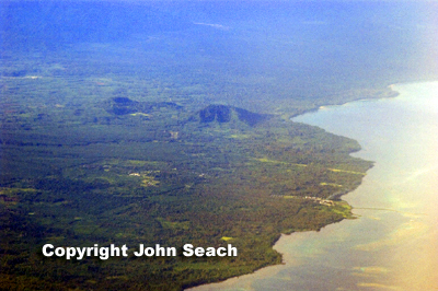
Karai Volcano, Sulu Range - John Seach
2006 Eruptions
Eruptions were reported at Karai volcano in Papua New Guinea in July 2006. This was the first historical activity recorded at the volcano. Seismic activity began on 7th July 2006.
Earthquakes were felt within the vicinity of Kimbe and as far as Bialla and Mamota, a distance of approximately of 1620km.
Earthquakes continued at five minute intervals. The affected population of 2,078 people, lives in Kaiamu, Malasi, Sulu and Silali villages. Weak to moderate white vapour emissions were observed. An overflight confirmed that emissions were coming from a NW-S-trending area between Ubia and Ululu cones. There were unconfirmed reports of vegetation die off from February 2006. An explosion was heard from Mato Hotspring on 15th August 2006. Moderately strong sulphur smell from the Silanga and Talopu hot springs were reported in October 2006.
1985 Earthquake
In 1985 a magnitude 7 earthquake hit SE of Sulu Range.
After the earthquake there was a temporary hot spring reported on the flank of Karai cone.
Further reading
Taranu, F., Collins, C., Miller, L., Mulina, K., White, R., Lockhart, A. and Cummins, P., 2007. The 2006 Earthquake Swarm in the Sulu Range, Central New Britain, Papua New Guinea. In poster presented at the 2007 Australian Earthquake Engineering Conference, Sydney.
Johnson, R.W., 1971. Bamus volcano, Lake Hargy area, and Sulu Range, New Britain: volcanic geology and petrology. Bureau of Mineral Resources, Geology and Geophysics.
Karai Volcano Eruptions
2006