Volcano Live
volcanolive.com
Karkar Volcano | John Seach

Madang Province, Papua New Guinea
4.649 S, 145.964 E
summit elevation 1839 m
stratovolcano
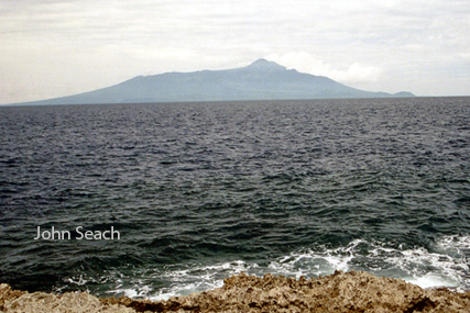
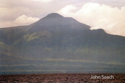
Karkar Island is located 64 km north of Madang. The island is 25 km long and 19 km wide with two summit calderas. The main caldera is almost perfectly circular 3.2 km in diameter with vertical walls 300 m high. Karkar is an andesitic stratovolcano, which is part of a chain of 15 volcanic islands in the western part of the Bismarck volcanic arc.
Karkar volcano, Papua New Guinea
Karkar Island
Activity at Karkar volcano includes Strombolian and phreatic eruptions.
There was an increase in thermal activity and gas emission from SE and SW flanks of Bagiai cone in 2007. Vegetation was killed. In February 2008, 15-20 volcanic earthquakes were measured daily at the volcano.
2013 Eruptions
A volcanic ash plume to 14,000 ft altitude drifting 20 nautical miles NE was reported on 29 January 2013. A high level eruption occurred at Karkar volcano, Papua New Guinea on 26th February 2013. Ash reached 30,000 ft altitude. Ash reached 28,000 ft altitude and drifted 40 nautical miles north on 16th March 2013. Aviation code was raised to RED.
2012 Activity
Possible ash emissions were observed by satellite at Karkar volcano on 1st February 2012.
1997 Activity
The last volcanic activity from Karkar was in September 1997 when fumarolic gases killed vegetation.
1979 Eruption and Fatalities
Explosive eruptions began at Karkar volcano in January 1979, after six months of increased seismic and fumarolic activity. On 8th March at about 0100 hr an phreatic eruption ejected incandescent tephra which was visible from the New Guinea mainland 30 km away. The eruption killed two volcanologists (Robin Cooke and Elias Ravian) who were camped at the volcano.
1978 Activity
An increase in sesimic activity began at Karkar volcano on 10th July 1978, and continues up until the January 1979 eruption.
1974-75 Eruption
Eruptions began on 14th February 1974 and continued until 8th August 1974. Basaltic-andesite lava flowed from two vents on SE flank of Bagiai cone on the caldera floor. Stromolian eruptions occurred from vents near the summit. Eruptions resumed in January 1975 with new effusive and explosive vents. Mild vulcanian eruptions occurred between April and June 1975.
1895 Eruption
Karkar volcano began to erupt on 17th June 1895.
1885 Eruption
Smoke and ash were observed at the volcano.
1643 Eruption
On 20th April 1843 Tasman saw "a great flame come steadily from the top of the mountain".
Further reading
McKee, C.O., Wallace, D.A., Almond, R.A. and Talai, B., 1981. Fatal hydro-eruption of Karkar volcano in 1979: Development of a maar-like crater. In Cooke-Ravian Volume of Volcanological Papers (Vol. 10, pp. 63-84). Geological Survey of Papua New Guinea.
McKee, C.O., Cooke, R.J.S. and Wallace, D.A., 1974. 75 Eruptions of Karkar volcano, Papua New Guinea. Volcanism in Australasia. Elsevier, Amsterdam, pp.173-196.
Karkar Volcano Eruptions
2013, 2012?, 1980?, 1979, 1974-75, 1974, 1962?, 1895, 1885, 1830?, 1643