Volcano Live
volcanolive.com
Mayon Volcano | John Seach

Albay Province, Luzon, Philippines
13.257 N, 123.685 E
summit elevation 2462 m
stratovolcano
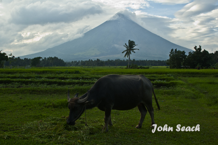
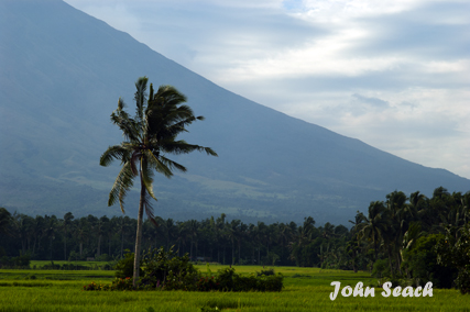
Mayon volcano is a beautifully symmetrical volcano with a steep upper slope of 35-40° and is capped by a small summit crater 200 m in diameter. Mayon eruptions produce lava flows, pyroclastic flows and mud flows which threaten populations at the base of the volcano.
A 6 km radius permanent danger zone is in place around the volcano. This is due to the possibility of sudden phreatic eruptions and rockfalls from the upper and middle slopes of the volcano.
Mayon volcano photos by John Seach
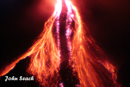
Mayon volcano eruption 2006
Mayon volcano eruption 2006
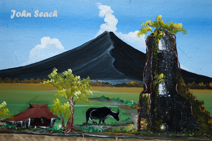
Mayon volcano painting

Legazpi city, at the base of Mayon volcano
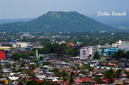
Lignon Hill, Legazpi city
Mayon Volcano - John Seach
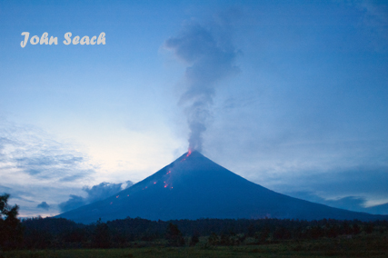
Mayon volcano 2006

Legazpi City, Philippines
Mayon Volcano has had a long history of destructive eruptions. The first recorded eruption occurred in 1616, and since that time about 40 eruptions have claimed more than 1500 lives.
2023 Eruption
Eruptions in 2023 at Mayon volcano included collapses of the lava dome and from the lava flows with incandescent rockfalls and pyroclastic flows.
2018 Eruption
Activity at Mayon volcano began with a phreatic eruption on 13
January 2018. On 14th January 2018, alert raised to level 3.
Effusive lava dome observed at summit, and small lava fountaining on
15-16 January. On 22nd January a phreatomagmatic eruption produced a
5-km high ash plume. On 22-23 January, lava fountains up to 700 m
high occurred at the summit. Pyroclastic flows occurred on 29th
January. During the first week of February, lava flows on the
volcano flank and small lava fountaining occurred.
20th December 2009
Mayon volcano was raised to level 4 alert (out of maximum 5) at 2:30
pm on 20th December (local time). During the previous 24 hours, 222
volcanic earthquakes were recorded at Mayon volcano, Philippines.
One explosion occurred which produced a plume rising 500 m above the
summit. Harmonic tremors were continuously recorded by the seismic
instruments. There was an intense crater glow at night and
incandescent lava continuously rolled down the slopes. A lava flow
extends 4.5 kilometers downslope from the crater along Bonga-Buyuan
Gully. Sulphur Dioxide emission increased from 2,034 to 7,024 tonnes
per day. At least 40,000 people have been evacuated from the danger
zone surrounding Mayon volcano, Philippines. Evacuation centers have
been set up in Camalig, Daraga, Malilipot, Sto. Domingo, and
Guinobatan towns; and Legazpi, Tabaco and Ligao Cities. Residents
are being removed from a 7-km Extended Danger Zone on the southeast
flank of the volcano. A lahar risk is present on the southern side
of the volcano, and residents have been warned to avoid river
channels, especially after periods of rainfall.
19th December 2009
Intensified activity occurred at Mayon volcano, Philippines over the
past 24 hours with 197 volcanic earthquakes. There were 18
explosions and emissions reached a maximum height of 2000 m above
the summit. Harmonic tremor was continuously recorded by the
seismometers. Night observation showed an intensified crater glow
and continuous avalanche of incandescent materials down the slopes.
The lava flow has extended 4 kilometers downslope from the crater
along Bonga Gully. Sulphur Dioxide emission increased from 1,065 to
2,034 tonnes per day.
18th December 2009
An increase in eruptions has occurred at Mayon volcano, Philippines
over the past day. A total of 248 volcanic earthquakes and tremors
were recorded by the seismic network. Fifty of these events were
explosions. The explosions produced dark gray to dark brown ash
columns that reached a maximum height of 1 km above the summit and
drifted southwest. The lava flow has reached 3 km down slope from
the crater, and incandescent fragments from the lava dome
continuously roll down Bonga Gully reaching about 4 km down slope.
Sulphur Dioxide emission rate is still high at 1,065 tonnes per day.
17th December 2009
More than 30,000 people have been evacuated from an eruption of
Mayon volcano in the Philippines. The Philippine Institute of
Volcanology and Seismology raised the alert level for the Mayon
volcano Monday night to 3 out of a maximum 5, indicating a larger
eruption could occur "within days to weeks." There are at least
50,000 people who need to be moved to a safer location. Most of the
residents that are targeted for forced evacuation are on the
southern side of the volcano around Camalig, Daraga and some parts
of Legazpi City. The volcano is showing signs of increased activity,
including an increase in volcanic earthquakes, strong crater glow,
and lava flows. During the past 24 hours quiet extrusion of lava and
incandescent lava fragments rolled down Bonga valley. The lava front
extended 800 m from the crater, and detached fragments reached a
distance of 4 km. Detached lava fragments produced a small secondary
pyroclastic surge southwest of the volcano, and produced light
ashfall in the municipalities of Camalig and Guinobatan. Seismic
monitoring measured 78 volcanic earthquakes and tremors. The
volcanic earthquakes are caused by magma ascent towards the crater,
and the tremors were associated with the detached fragments of lava
and rockfalls.
11th November 2009
An ash eruption occurred at Mayon volcano, Philippines at 1:58 am on
11th November 2009. An explosion earthquake lasting 3 minutes was
accompanied by rumbling noises and ejection of incandescent
fragments on the upper slopes. Ash fell on the southwest side of the
volcano. Twenty volcanic earthquakes were recorded over the past 24
hours. A 6 km radius Permanent Danger Zone and 7 km Extended Danger
Zone on the southeast flank of the volcano are off limits due to the
threat of explosions and rockfalls.
9th August 2009 Ashfall was reported
at Tabaco City and areas of Guinobatan town, surrounding Mayon
volcano in the Philippines. Seismic activity did not indicate an
eruption, and visual observations were not possible due to
meteorological cloud in the area. There is a possibility that strong
winds mobilised old ash deposits, or rockfalls caused the ashfall.
In the past 24-hour observation period, PHIVOLCS reported 1,308 tons
of sulfur dioxide emission from the volcano. Mayon remains at alert
level 2, and there is a 6 km permanent exclusion zone, and 7 km
extended danger zone at the southeast flank of the volcano. If the
Philippine Institute of Volcanology and Seismology raises the
volcano alert to level 3, 13,458 families or 47,018 people from the
two cities and five towns would be evacuated to safer areas. People
are advised to avoid the danger zone due to risk of pyroclastic
flows, explosions and lava flows. Village leaders around the volcano
have been issued with mountain bikes, megaphones, whistles,
pocket-sized AM/FM transistor radios , flashlights and basic life
support kits, to assist any evacuation.
July 2009 There are signs of unrest at Mayon
Volcano in the Philippines after an increase in summit crater glow
has been observed in July. This is caused by a rise in magma levels
at the volcano. The Philippine Institute of Volcanology and
Seismology has also recorded an inflation of the volcano. Alert
level one is maintained at Mayon volcano and residents and tourists
are advised not to enter the 7 km radius extended danger zone.
Mayon volcano in the Philippines was raised from Alert Level 1 (low
level unrest) to Alert Level 2 (moderate unrest) on 10th July 2009.
Beginning June 2009 seismic activity increased to the same level
when a phreatic explosion occurred last August 2008. Ground uplift
of one centimetre has been measured, and a summit glow was visible
from Lignon Hill Observatory. An aerial survey on 8th July, 2009,
showed a cone-shaped pile of hot, steaming old rocks at the summit.
The low frequency volcanic earthquakes and ground uplift may
indicate that new magma is rising towards the surface. A 6-km radius
Permanent Danger Zone and the 7-km Extended Danger Zone on the
southeast flank of the volcano are off-limits at Mayon volcano.
2008 Eruption
On 10th August 2008, an explosion occurred at Mayon volcano in
Philippines. Ash reached 9000 ft altitude and drifted ENE. During
the weeks prior to the eruption, there was visible glow at the
crater, and increasing seismicity.
2006 Eruption
Eruptions of Mayon volcano in August 2006 resulted in evacuation of
48,000 people, and 1266 people were killed in December 2006 when
heavy rain from typhoon Durian caused landslides and floods at the
base of the volcano. Lessons from eruption of Mt Pinatubo in 1991
had been forgotton.
1984 Eruptions
An eruption began on 10th September 1984 with lava spilling over the
crater rim. Incandescent blocks rolled 600 m down the NW flank,
destroying trees. On 12th September eruptions became Vulcanian in
character with pyroclastic flows extending several kilometers from
the summit, and ash emissions rising to a height of 15 km.
1981 Mudflows
On 30th June 1981, typhoon Daling triggered mudflows which killed 40
people, injured nine, and left seven missing.
1978 Eruption
An eruption began at Mayon volcano on 7th May 1978 and gradually
increased in intensity, reaching a maximum on 22nd May. An aa lava
flow emerged from a breach in the summit crater wall and extended
down the SW flank directly over the 1968 flow. Activity intensified
on 7th March, with ash emissions and incandescent material were
ejected. 8000 people were evacuated.
1968 Eruptions
Eruptions began at Mayon volcano on 21st April 1968. By 15th May
more than 100 explosions had occurred, 6 people had been killed, and
roughly 100 square km had been covered by ashfall, blocky ash flows,
and a lava flow. Explosions from the summit crater ejected large
quantities of ash and incandescent blocks to a height of 600 m and
ash plumes 10 km high. Nuees ardentes descended southwest and
reached 7 km from the summit down to an elevation of 200 m. On 27th
April a large explosion breached the southwest crater rim and was
followed by a viscous aa lava flow which began moving slowly down
the southwest flank.
1897 Eruption
A severe eruption began at Mayon volcano on 23rd June 1897. Lava
flowed down the side of the volcano for seven miles towards the
east. Volcanic ash fell on the surrounding country for 100 miles to
the east and 75 miles to the west. The eruption finished on 30th
June 1897 and killed 350-400 people.
1814 Eruption
The eruption of Mayon in 1814 was the most destructive historical
eruption at the volcano. The six hour eruption killed 1200 people.
Fatalities were caused by pyroclastic density currents, port
eruption lahars, and fires set alight by hot tephra.
Further reading
Newhall, C.G., 1979. Temporal variation in the lavas of Mayon Volcano, Philippines. Journal of Volcanology and Geothermal Research, 6(1-2), pp.61-83.
Moore, J.G. and Melson, W.G., 1969. Nuees ardentes of the 1968 eruption of Mayon volcano, Philippines. Bulletin Volcanologique, 33(2), pp.600-620.
Mayon Volcano Eruptions
2023, 2022, 2018-19, 2014, 2013, 2009-10, 2008, 2006, 2004, 2003, 2002, 2001, 1993, 1984, 1978, 1968, 1947, 1943, 1941, 1939, 1938, 1928, 1900, 1897, 1896, 1895, 1893, 1891-92, 1890, 1888, 1886-87, 1885, 1881-82, 1876, 1873, 1872, 1871-72, 1868, 1863?, 1862, 1861, 1860, 1859, 1858, 1857, 1855, 1853, 1851, 1846, 1845, 1839, 1834-35, 1827-28, 1814, 1811?, 1800, 1766, 1616.