Volcano Live
volcanolive.com
Ontong Java Atoll & Plateau | Dr John Seach
Last updated: January 2026

Malaita Province,
Solomon Islands
~5.00 S, 159.00 E
highest elevation 13 m (atoll islands)
Volcanic atoll (Large Igneous Province remnant)
Ontong Java Atoll is the northernmost land in the Solomon Islands, a vast coral atoll (~1400 sq km lagoon, 12 sq km land) built atop the immense Ontong Java Plateau. The atoll comprises ~122 small islands, with the highest point only 13 m above sea level. Nukumanu Atoll (Papua New Guinea) lies ~50 km north.
Warning: Ontong Java is extinct with no activity for ~120 million years. Volcanic hazards are negligible. The remote atoll poses general risks from ocean conditions and isolation.
Geology and Volcanology
The Ontong Java Plateau is the world's largest oceanic Large Igneous Province (LIP), covering ~1% of Earth's surface (~5 million sq km, comparable to Alaska in area). It formed by massive flood basalt eruptions primarily ~122 million years ago (Early Cretaceous), with minor phases ~90 Ma. The plateau's thickness reaches ~30-40 km, representing one of the greatest outpourings of magma in geologic history. The modern atoll developed on the subsided plateau surface.
Current Activity (January 2026)
No volcanic activity has been recorded at Ontong Java. The plateau is extinct with no geothermal or seismic manifestations. Satellite observations show no anomalies. The feature remains geologically inactive.
Infographic: The Great Cretaceous Outpouring - Ontong Java's Fiery Past
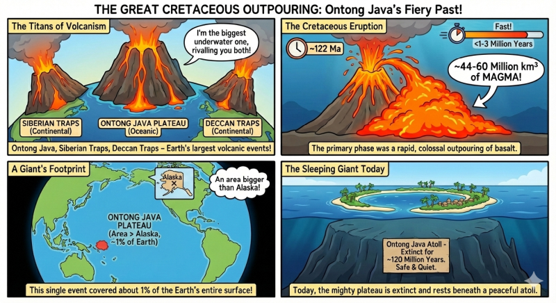
The Ontong Java Plateau represents one of the largest volcanic events in Earth's history (~122 Ma), rivaling the Siberian and Deccan Traps. Primary phase emplaced ~44-60 million kmł of basalt rapidly, covering an Alaska-sized area underwater. Today the extinct giant sleeps beneath a tranquil atoll.
Major Cretaceous Eruption (~122 Million Years Ago)
The Ontong Java Plateau represents one of the largest volcanic events in Earth's history, rivalled only by the Siberian Traps and Deccan Traps in volume and scale. The primary eruptive phase ~122 Ma emplaced ~44-60 million cubic km of basaltic magma in a geologically short period (possibly <1-3 million years), covering an area larger than Alaska.
This massive flood basalt event likely had profound global impacts, including significant CO2 release contributing to Cretaceous greenhouse conditions, ocean anoxia, and potential links to biotic changes. The eruptions occurred in a submarine environment, producing thick pillow basalt sequences. The plateau's formation remains debated—mantle plume vs. other mechanisms—but its volume exceeds most known LIPs. Secondary pulses ~90 Ma added minor volume.
Further reading
Hanyu, Takeshi, et al. "Collision-induced post-plateau volcanism: Evidence from a seamount on Ontong Java Plateau." Lithos 294 (2017): 87-96.
Fitton, J.G. ed., 2004. Origin and evolution of the Ontong Java Plateau. Geological Society of London.
Ontong Java Plateau Eruptions
Primary phase ~122 Ma (Early Cretaceous, ~44-60 million cubic km)
Secondary phase ~90 Ma
Extinct