Volcano Live
volcanolive.com
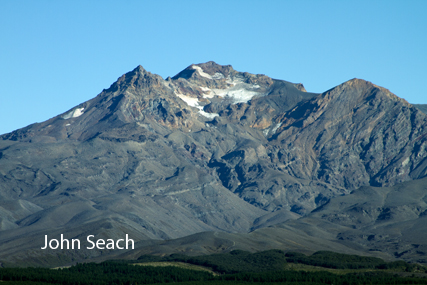
Ruapehu Volcano | John Seach

North Island, New Zealand
39.28 S, 175.57 E
summit elevation 2779 m
stratovolcano
Ruapehu is one of New Zealand's most active volcanoes, and the highest mountain on the north island. Ruapehu is located at the southern end of the Taupo Volcanic Zone. The volcano is composed of andesite, and contains a single vent and a crater lake.
Ruapehu volcano photos by John Seach
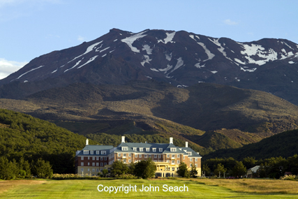
Ruapehu volcano - John Seach
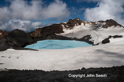
Ruapehu crater lake 2010 - John Seach
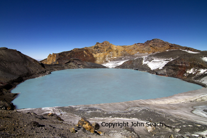
Ruapehu crater lake 2011 - John Seach

Ruapehu volcano - John Seach
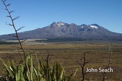
Southern side of Ruapehu volcano
Southern flank of Ruapehu volcano
2020 Unrest
An increase in unrest has been reported at Ruapehu volcano in March 2020. Seismic activity increased since at the end of February 2020. The crater lake heated from 24 to 30 deg C. Alert level remained unchanged at 1 (on a scale of 0 to max 5).
2015 Avalanche
An avalanche of ice and snow into the summit crater lake occurred overnight at Ruapehu volcano on
25th August 2015. There was a rapid temporary drop in lake temperature from 15 to 8 deg C. The lake temperature returned to 15 Deg C in the following few hours. There was no effect on the activity at the volcano.
2012 Unrest
Ruapehu volcano was increased to yellow alert on 16th November 2012 due to unrest under the crater lake. An increase in earthquakes began in late October 2012, 5 km below the crater lake. The temperature a few hundred metres below the lake was 800 deg C, and 20 deg C at the surface.
September 2007 Eruption and Lahar
A hydrothermal eruption occurred at Ruapehu on 25th September 2007. The eruption column reached 15,000 ft and two lahars were produced. The lahar to the north down the Whakapapa Valley reached into the skifield, while the floods down the Whangaehu Valley reached to just beyond the National Park Boundary.
March 2007 Lahar
A lahar occurred at Mt Ruapehu volcano on 18th March 2007. A wall of debris 300 m long, consisting of trees, branches, and rocks flowed down the Whangaehu River at the front of the lahar. The Department of Conservation rated the lahar as moderate. The river level rose by 2 metres and temporarily closed a road. The lahar was caused by a small breach in Ruapehu crater lake wall, which released water for about 45 minutes. The partial collapse of the volcano crater lake rim set off emergency warning systems, and the lahar was tracked flowing down the mountain. About 200 train passengers were stranded when the northbound Overlander train was stopped at Waiouru. Passengers were transferred to busses to complete the journey. The lahar passed over farm land and headed towards the sea. Weeks prior to the lahar a warning stated: "Melting snow at Ruapehu volcano has filled the summit crater lake to within 1.5 metres of the rim. A lahar is likely within weeks down the Whangaehu River."
2006 Hydrothermal Eruption
A small hydrothermal eruption occurred on 4th October 2006. Tsunamis in the crater lake reached a height of 5 m, but did not overflow the crater rim.
1997 Eruptions
During 9-12 October, minor steam and mud eruption were observed in the crater lake. A 1 km exclusion zone was placed around the crater lake.
1996 Eruptions
A series of eruptions occurred 16-18 June 1996 which quickly empted the crater lake, and was accompanied by ash column to several kilometres above the summit. Molten material was erupted hundreds of metres above the crater and bombs ejected to 1.5 km from the crater.
1995 Eruptions
Vent clearing eruptions occurred on 29th June and 3rd July. Larger eruptions began in September with plumes reaching an altitude of 12 km. On 18th September an eruption was accompanied by a magnitude 3.6 earthquake, and a lahar which traveled 57 km, and destroying a hiking bridge.
1975 Eruption
A large phreatic eruption occurred at Ruapehu volcano on 24th April 1975. The eruption expelled 1.6 million cubic metres of water from the crater lake. Lahars drained from the summit and damaged ski installations, bridges, and hydro-electric power
scheme constructions. The eruption was considered to be similar the the 1946 Bikini atoll underwater nuclear explosion.
1969 eruption
An eruption of Ruapehu volcano on 22nd June 1969 was the largest at the volcano since 1945.
1953 Eruption and Train Disaster
On 24th December 1953 a lahar destroyed a rail bridge 42 km from the volcano, as a Wellington-Auckland passenger train was crossing. The accident resulted in 151 fatalities.
1945 Eruption
From March 1945 to
January 1946, the eruption of Ruapehu volcano passed through five phases of activity: steaming, tholoid, lava, ash, and solfatara.
At least five other vents have been active during the Holocene.
Further reading
Price, R.C., Gamble, J.A., Smith, I.E., Maas, R., Waight, T., Stewart, R.B. and Woodhead, J., 2012. The anatomy of an Andesite volcano: a time–stratigraphic study of andesite petrogenesis and crustal evolution at Ruapehu Volcano, New Zealand. Journal of Petrology, 53(10), pp.2139-2189.
Gamble, J.A., Wood, C.P., Price, R.C., Smith, I.E.M., Stewart, R.B. and Waight, T., 1999. A fifty year perspective of magmatic evolution on Ruapehu Volcano, New Zealand: verification of open system behaviour in an arc volcano. Earth and Planetary Science Letters, 170(3), pp.301-314.
Ruapehu Volcano Eruptions
2007, 2006, 1997, 1996, 1995, 1994?, 1992, 1991?, 1990, 1988-89, 1988, 1987, 1986, 1985, 1981-82, 1980, 1979-80, 1979, 1977-79, 1976, 1975, 1973-74, 1972-73, 1971, 1970, 1969, 1968, 1967, 1966, 1959, 1956, 1952, 1951, 1950, 1948, 1946-47, 1945, 1944, 1942, 1940, 1936, 1934-35, 1934, 1925, 1921, 1918, 1906, 1903, 1895, 1889, 1861